Adriatic winds
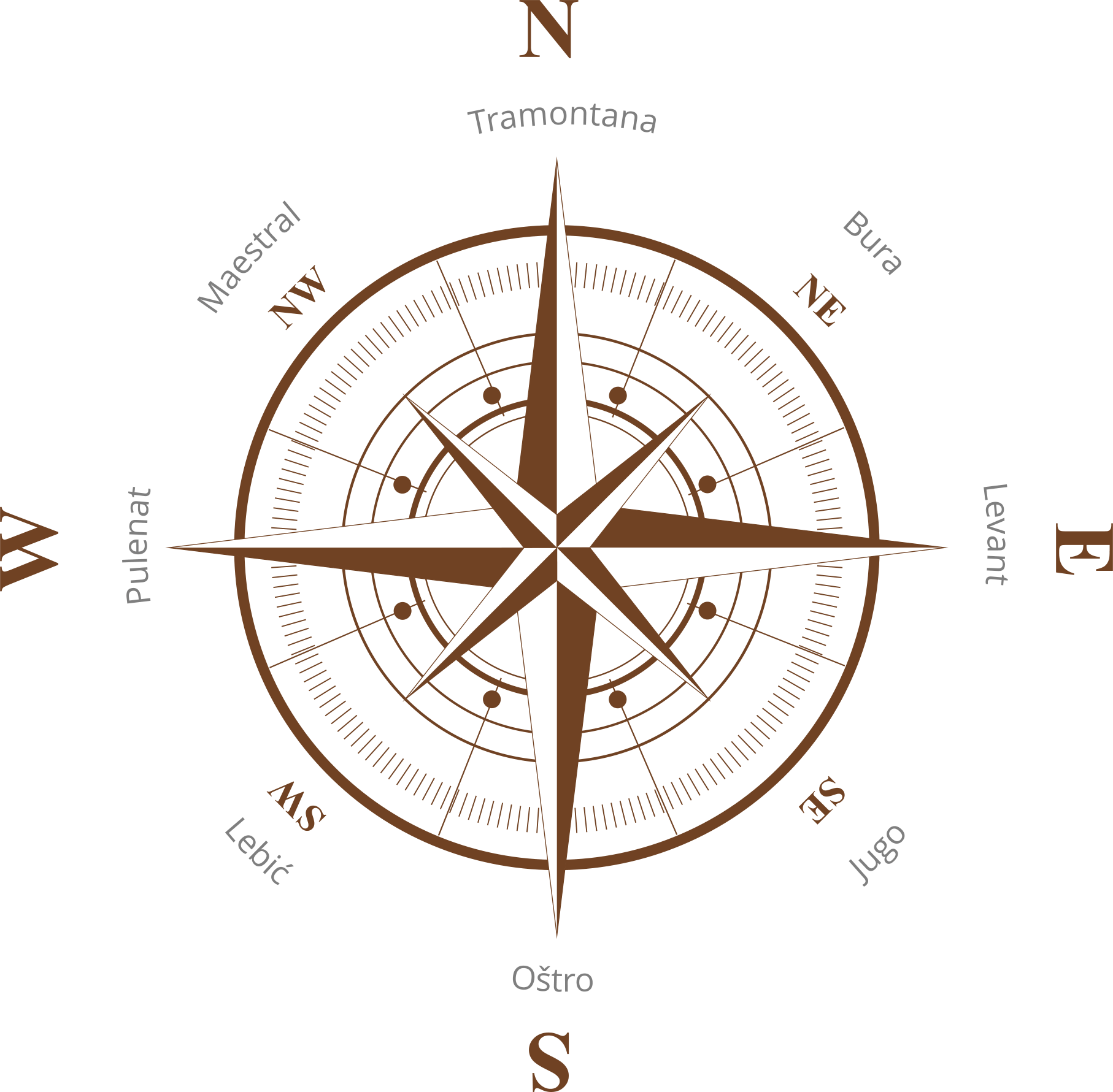
Tramontana
North ⇛ South
The wind starts to blow after the cold front and blows from the north. Tramontana is transitional in nature and most commonly develops into the Bora. Tramontana starts blowing suddenly and can reach the power of a hurricane. It is usually an indicator that extreme weather conditions will follow. It usually lasts for a day and can be quite unpredictable and shifty, generating large waves. Sailboats are not recommended to sail in such a wind as it can reach up to 200km/h.
Burin
North-East ⇛ South-West
Burin is a coastal wind and is caused by differences in temperature between the sea and the land. It is a thermal wind that usually blows during the evenings and night hours, when the land is colder than the sea and the wind equalizes the difference. Burin blows in the almost the same direction as the Bura, but at a much more pleasant force.
Bura / Bora / Burja
North-East ⇛ South-West
The wind blowing in gusts, usually from the northeast. When this high-pressure wind comes tumbling down towards the sea from the mountains, it gains momentum, often reaching gusts of 80 knots. It is certainly the coldest and the most powerful wind. The strength of the Bora weakens as we move away from the shore. It's causing rough seas and it's breaking waves. Bura blows a cold wind under sunny skies often lasting for several days - in the winter it can last for several weeks, but it can also last for only an hour in the summer.
Levanat / Levant
East ⇛ West
Levanat is a moderate traditional wind that, in wintertime, occurs when Jugo turns to Bura and in summertime, it is a breeze in the morning that turns into the favorable Maestral. Levanat is most prone to blow for a couple of days in a row from February to March bringing clouds and rainfall. Levanat brings good sailing conditions although it is not so popular as it is usually a very cold wind.
Jugo / Sirocco
South-East ⇛ North-West
Jugo is warm and humid wind that brings changeable weather, usually precipitation as well. Compared to Bura, it blows more evenly, and like Bura, it shakes the sea strongly. It causes high and choppy waves, with showers in between. It is a long-lasting wind as it can blow from six to nine days, and at intervals up to three weeks.
Oštro / Ostro
South ⇛ North
It is a short-lived transit wind that blows from south to north. It is a warm and humid wind that often carries rain, but it is also sometimes identified with Lebić and Jugo. In summer, it can only blow for a few hours.
Lebić / Lebeche / Lebič
South-West ⇛ North-East
Lebić blows from the southwest and causes big waves and rough seas. Due to the shape of the Adriatic bay, the wind quickly changes direction. The powerful Lebić usually brings high-tide, abundant rain, and wild waves and is known to destroy many south facing beaches and coastlines. It is formed during storms in the summer or when an anticyclone arrives from the southwest. It sometimes comes after Jugo or after the passing of a cyclone and tends to last a few hours only.
Pulenat / Ponente / Ponent
West ⇛ East
Pulenat is a rare and unfriendly wind, more popular in the northern Adriatic, and you can foresee it coming, as it takes form in very unusual phases. At first, the sea and wind would be almost at a stand-still, then clouds form from the west, followed by gusts, and then once again there is the “quiet before the storm”, before Pulenat pays a visit with high waves and extremely dangerous conditions, particularly in longitudinal channels. A powerful Punenat tends to creates havoc on west facing beaches and promenades. It is short-lived and can blow at any time of the year.
Maestral / Maestro / Mistral
North-West ⇛ South-East
Maestral is a pleasant coastal wind that blows from north to south. The wind starts to blow in the morning between 9.00 and 10.00, and intensifies until 14.00, when it reaches its maximum strength. In case the Maestral does not blow for several hours in the evening, it means that the weather will be bad. Maestral blows during the summertime and can at times reach up to 30 knots.
Wind rose
The wind rose is a graphical representation used by meteorologists to display constant winds for a specific area. A certain wind, represented in a wind rose, blows in the direction towards the center of the rose. For an example, Tramontana on the Adriatic wind rose, blows from North to South.